
Forecasters are warning of a fresh batch of rain that is due to slam already drenched areas of the country tomorrow.
The Marlborough District Council says residents in low-lying areas should be ready to evacuate at a momentâs notice as more rain threatens to fall.
Meanwhile, Auckland and Northland residents are being warned to expect heavy rain and strong, blustery winds to hit during peak commute times tomorrow morning.
MetService meteorologist Lewis Ferris said their main focus as this weather system crosses over is the top of the South Island.
âIf we hadnât had the last few weather systems that weâve had over the last couple of weeks, it wouldnât be so much of an issue, but itâs another burst, although relatively short, but quite heavy for around that sort of 12-hour period on to very saturated soil.
âSo if youâve read the warnings, we do have a moderate or high risk of upgrade to a red warning.
âSo by that, weâre talking about the likelihood of impacts has been heightened by the rain that weâve seen recently.â
A state of emergency for the Tasman region was lifted on Monday after it was inundated with floodwaters caused by last weekâs heavy rainfall, dubbed by local authorities as a âone-in-100-year eventâ.
Homes were left uninhabitable, roads damaged, and properties were inundated with floodwaters.
Nearly 650 properties in the region were assessed, with 90 of those encouraged to seek further support.
Last week, the Government unlocked extra support for flood-affected farmers and growers, making up to $100,000 available to support and co-ordinate recovery efforts.
 Flood-damaged furniture lies in the front yard of a house along the Motueka Valley. Photo / Tim Cuff
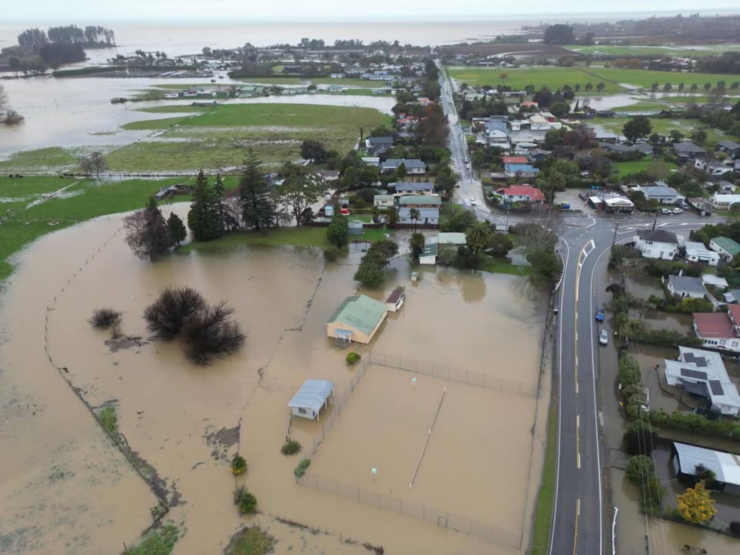 Aerial photos show extensive flooding in Riwaka, near Motueka. Photo / James Thomas
Marlborough Emergency Management group manager Matt Kerr said there was a risk some situations could be exacerbated in already fragile areas.
âWe want to get advice out to our communities,, including Spring Creek, RÄrangi, Northbank, Kenepuru Rd and Port Underwood that readiness remains important.
âAlthough Friday eveningâs weather is predicted to move through quickly, we encourage people to take stock of their preparedness, remain in touch with friends and whÄnau and to have plans in place for safety and support.â
Heavy rain to hit Auckland during morning commute
Ferris said that for Auckland, there was the potential for heavy rain during the morning commute tomorrow.
He said the heavy rain would be coupled with âstrong, blustery windsâ and would also affect Northland.
âThese are regions that have seen plenty of rain recently. So itâs that idea that those impacts, like surface flooding or maybe even some slips, could just come about a bit quickly.â
Ferris said rain is also forecast for areas further down the country in Taranaki, Waikato and Bay of Plenty.
The rainfall accumulations arenât shaping up to be as large but are not completely out of line with potential severe weather, Ferris said.
A heavy orange rain warning has been issued for Northland and Auckland for 16 hours from 6am tomorrow, and Great Barrier Island, Coromandel Peninsula and Waikato for 15 hours from 11am tomorrow.
The same warnings have been issued for Mt Taranaki from 11am; Nelson, about and southeast of Motueka and north of Lake Rotoroa; Marlborough, northwest of the Awatere Valley from 9am; and Tasman District northwest of Motueka.
A heavy rain watch has been issued for Bay of Plenty, including Rotorua from 1pm tomorrow, Waitomo, Taumarunui and Taupo from 2pm tomorrow and Taranaki north of the mountain from 11am tomorrow.
An orange strong wind warning has been issued for Taranaki south of the mountain from midday tomorrow, and a strong wind watch has been issued for Taihape, Whanganui and Banks Peninsula for tomorrow afternoon.
Looking forward to the weekend, Ferris said the weather is not going to improve.
âAs we move through Saturday, it looks like the band of rain, bringing that severe weather, has moved off to the east, but we do hold on to a quite showery, messy weather situation through the weekend.
âMost of that weather is for western areas, but itâs not as though many people should expect a sort of picture-perfect weekend after the rain on Friday.â
Take your Radio, Podcasts and Music with you
Get the iHeart App
Get more of the radio, music and podcasts you love with the FREE iHeartRadio app. Scan the QR code to download now.

Download from the app stores
Stream unlimited music, thousands of radio stations and podcasts all in one app. iHeartRadio is easy to use and all FREE


